EFFORTS OF UNIVERSITY OF TSUKUBAEfforts of University of Tsukuba

Tracing Water Cycle Through Combined Use of Isotopes, Numerical Models and GIS
In order to maintain a healthy water cycle and achieve sustainable water management, it is essential we understand the water cycle’s actual conditions. Therefore, in this project, we conduct research in order to clarify the path and source of the water cycle by combining a stable isotope tracer for the hydrogen and oxygen that make up water molecules, with numerical models and a geographic information system (GIS).
So far, we have developed a precipitation isotope ratio observation network in the mountainous area of the central Japan and created an isotope map using GIS to build a water and isotope cycle model which uses those as input. Our findings include the following:
- Runoff forecasting in a basin with poor river discharge data
- Clarification of water use strategies and species interactions for plants
- Estimation of groundwater recharge elevation for domestic water sources
- Plant communities-basin scale evapotranspiration separation
- Identification of circulating and non-circulating hot springs
- Clarification of elevation dependency for lake water balance
- Quantification of the rate of contribution of melting snow to spring river runoff
Moving forward, we will improve our methodology and accumulate more case studies, for instance, from the perspective of water cycle response according to global warming and water source supply functions as ecosystem service.

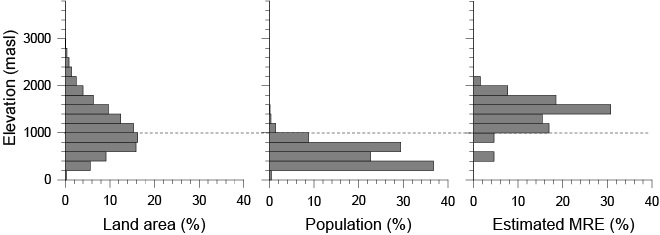
Fig. Population (middle) and groundwater recharge areas for domestic water (right) imbalanced distribution vs elevation distribution of the Nagano and Yamanashi Prefecture areas (left)
Associate Professor, Faculty of Life and Environmental Sciences, University of Tsukuba
SUZUKI Keisuke
Professor, School of Science, Shinshu University


